Michigan Townships Association
 Navigating high waters—April/May 2020 Township Focus
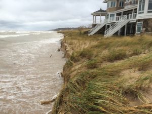
With the record-high water levels, Michigan experienced in recent years, communities and residents across the state faced flooding, crumbling infrastructure, erosion and loss of property for for shoreline and inland communities. The Michigan Department of Environment, Great Lakes and Energy (EGLE) have indicated the erosion occurring is comparable to 1986, when it was then recorded as the highest water level seen in a century.
MTA joined local, state and federal officials in Michigan’s first High Water Coordinating Summit to collaborate and share resources to respond to public health and safety challenges. Summit participants–including Director of Member Information Services Michael Selden—agreed to form the “Michigan High Water Team,” an ad hoc team focused on identifying available assets for high water incidents and helping coordinate communication between agencies and local governments to keep residents informed.
Stabilization permits
At this time, a permit is needed for a proposed structure from both EGLE and the U.S. Army Corps of Engineers. To make the joint permit process easier and more streamlined, it can be completed online. A “Minor Project” category was established for sandbag stabilization. This means a faster permit processing for homeowners and a reduced fee of $100. A public notice is also not necessary for meeting review requirements.
Anyone with questions can contact the Environmental Assistance Center at 800-662-9278 and indicate you are calling about “high water” or email EGLE-assist@michigan.gov.
Additional resources
Michigan Department of Environment, Great Lakes, and Energy Great Lakes High Water Levels webpage
US Army Corps of Engineers Great Lakes (Detroit District) High Water website
Includes a webpage that tracks water levels of the Great Lakes and links to permit applications, frequently asked questions, a damage assessment survey for property owners, and more.
Coastal Community RESILIENCE grants
With matching funding from Michigan’s Coastal Management Program, the Land Information Access Association is collaborating with Michigan coastal communities to develop master plan content that will contribute to greater coastal and community-wide resilience. These planning efforts focus on ways to respond to a changing climate with more severe storms, and respond and adapt to dynamic changes in Great Lakes water levels.